Turnagain Pass Avalanche Forecast
|
![]() ![]() |
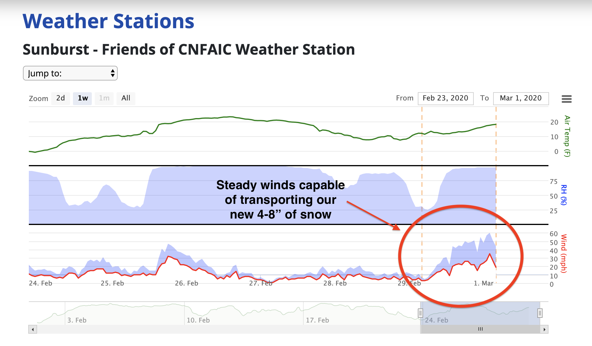
The avalanche danger is CONSIDERABLE today at all elevations. Relatively warm temperatures, steady 20mph winds gusting to 60mph, and 4″-8″ of new snow make it likely for a person to trigger a storm slab or wind slab. Additionally, it remains possible for a human to trigger a weak layer buried 3-6′ beneath a dense slab. If initiated, the resulting avalanche could be very large and have dangerous consequences. Cornices continue to develop and should be avoided. Choose routes with intention and use good travel protocol.
SUMMIT LAKE TO SEWARD REGION: The likelihood for triggering a large slab avalanche is higher due to a weaker snowpack and wind effect. Extra caution is advised.
Alaskans! Help us reach $20,000 in 2020 for Chugach Avy’s 20th anniversary next winter. Pick.Click.Give. some or all of your PFD to Friends of the Chugach National Forest Avalanche Info Center. Your donation pre-pays your annual membership AND guarantees good snow karma for winter 2020/21. Thanks, Friends! Pick.Click.Give. link: for Friends of the CNFAIC.
Signal Word | Size (D scale) | Simple Descriptor |
Small | 1 | Unlikely to bury a person |
Large | 2 | Can bury a person |
Very Large | 3 | Can destroy a house |
Historic | 4 & 5 | Can destroy part or all of a village |
Temperatures increased yesterday afternoon to near 32°F at sea level as 4-8″ of new snow fell throughout the forecast region. With steady winds capable of transporting snow and gusting to 60mph, we’re likely to have new snow instabilities.
The new storm snow is falling on top of a layer of surface hoar formed 1.27-28. Although freshly formed storm slabs may be relatively shallow, if triggered they could take a rider or skier off guard and down slope. This may be a lower consequence avalanche concern, but keep in mind triggering a storm slab or wind slab could tip the balance and trigger our deep persistent slab concern discussed in problem 2.
Wind Slab: With moderate temperatures and new snow blowing around at the ideal wind speeds, formation of wind slabs on the lee aspects of ridges and gullies is likely. With buried surface hoar reported on all aspects and elevations, these could be touchy to trigger.
This surface hoar formed at all elevations and on all aspects on 2.27-28. This is now blown around or buried beneath yesterdays 4-8″ of new snow. 2.29.20 . Photo Andy Moderow
Cornices: As always, give cornices plenty of space and limit exposure under them.
Loose snow: “Sluffing” of loose snow is likely in steeper terrain and could entrain a rider.
Signal Word | Size (D scale) | Simple Descriptor |
Small | 1 | Unlikely to bury a person |
Large | 2 | Can bury a person |
Very Large | 3 | Can destroy a house |
Historic | 4 & 5 | Can destroy part or all of a village |
With below freezing temperatures and incremental loads of snow, our deep persistent slab is slow to adjust. Weak faceted snow from January is still 3-6 feet below the surface. Triggering and becoming caught in a slab of this size would likely have fatal results. Resist complacency – now is a good time to make choices for yourself based on your own knowledge, risk tolerance, and skill set. Things to keep in mind:
Yesterday: Cloudy skies preceded a storm system producing 4-8″ of snow. Ridgetop winds increased to the 20-25mph range overnight with gusts to 60mph. Temperatures were in the teens to 20’s°F at most locations.
Today: Cloudy skies with snow accumulation of 1-3″ today. Temperatures are expected to range from teens to low 20’s °F. Winds are forecast to settle down from the west at 5 to 10 mph.
Tomorrow: Mostly cloudy skies with temperatures in the single digits to low 20’s °F. Winds expected from the west at 5 to 15 mph. Intermittent showers through the day with minimal accumulation expected.
PRECIPITATION 24-hour data (6am – 6am)
Temp Avg (F) | Snow (in) | Water (in) | Snow Depth (in) | |
---|---|---|---|---|
Center Ridge (1880′) | 24 | 4 | 0.4 | 79 |
Summit Lake (1400′) | 23 | 3 | 0.4 | 32 |
Alyeska Mid (1700′) | 22 | 8 | 0.7 | 89 |
RIDGETOP 24-hour data (6am – 6am)
Temp Avg (F) | Wind Dir | Wind Avg (mph) | Wind Gust (mph) | |
---|---|---|---|---|
Sunburst (3812′) | 14 | ENE | 23 | 60 |
Seattle Ridge (2400′) | 18 | SE | 15 | 34 |
Date | Region | Location | Observer |
---|---|---|---|
05/22/23 | Turnagain | Avalanche: Tincan | Nick D'Alessio |
05/12/23 | Turnagain | Avalanche: Tincan, Sunburst, Magnum, Cornbiscuit | Heather Thamm |
05/07/23 | Turnagain | Observation: Tincan – Bear Tracks | CNFAIC Staff |
05/05/23 | Turnagain | Observation: Seattle Ridge | AS/ WW Forecaster |
05/02/23 | Turnagain | Observation: Cornbiscuit | Schauer/ Sturgess Forecaster |
05/02/23 | Turnagain | Observation: Seward Hwy Turnagain Pass | Joel Curtis |
04/30/23 | Turnagain | Observation: Magnum | Ayla, Kit Crosby, Barton |
04/29/23 | Turnagain | Observation: Tincan | John Sykes |
04/28/23 | Turnagain | Avalanche: Taylor Pass/Pastoral | Schauer/ Creighton Forecaster |
04/28/23 | Turnagain | Avalanche: Tincan | Andy Moderow |
Status of riding areas across the Chugach NF is managed by the Glacier and Seward Ranger Districts, not avalanche center staff. Riding area information is posted as a public service to our users and updated based on snow depth and snow density to prevent resource damage at trailhead locations. Riding area questions contact: mailroom_r10_chugach@fs.fed.us
Area | Status | Weather & Riding Conditions |
---|---|---|
Glacier District |
Subscribe to Turnagain Pass
Avalanche Forecast by Email
This is a general backcountry avalanche advisory issued for Turnagain Arm with Turnagain Pass as the core advisory area. This advisory does not apply to highways, railroads or operating ski areas.