Turnagain Pass RSS

Archives
ARCHIVED - Forecasts expire after 24 hours.
Issued
Fri, February 24th, 2023 - 7:00AM
Expires
Sat, February 25th, 2023 - 7:00AM
Forecaster
Andrew Schauer
Avalanche risk The Bottom Line

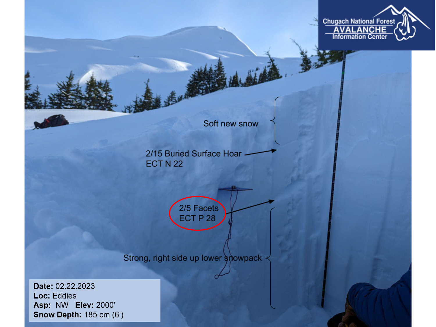
The avalanche danger is MODERATE above 1000′. It will be possible to trigger avalanches up to a foot deep on slopes where yesterday’s winds built a fresh round of wind slabs. The most likely places to find unstable snow will be at upper elevations near ridgelines, in steep gullies, and below convex rollovers. There is also a lingering chance of triggering a larger avalanche on a weak layer buried in the upper 2-3′ of the snowpack. The danger is LOW below 1000′.

LOST LAKE/ SEWARD/ SNUG HARBOR: It is looking like these southern areas will see a little more wind than the core advisory area today. It is likely a person will be able to trigger an avalanche on wind-loaded slopes where fresh wind slabs will be forming today.

Fri, February 24th, 2023
Alpine
Above 2,500'
2 - Moderate
Avalanche risk
Treeline
1,000'-2,500'
2 - Moderate
Avalanche risk
Below Treeline
Below 1,000'
1 - Low
Avalanche risk
0 - No Rating
1 - Low
2 - Moderate
3 - Considerable
4 - High
5 - Extreme
Avalanche risk Avalanche risk Avalanche risk Avalanche risk Avalanche risk
Travel Advice Generally safe avalanche conditions. Watch for unstable snow on isolated terrain features. Heightened avalanche conditions on specific terrain features. Evaluate snow and terrain carefully; identify features of concern. Dangerous avalanche conditions. Careful snowpack evaluation, cautious route-finding, and conservative decision-making essential. Very dangerous avalanche conditions. Travel in avalanche terrain not recommended. Extraordinarily dangerous avalanche conditions. Avoid all avalanche terrain.
Likelihood of Avalanches Natural and human-triggered avalanches unlikely. Natural avalanches unlikely; human-triggered avalanches possible. Natural avalanches possible; human-triggered avalanches likely. Natural avalanches likely; human-triggered avalanches very likely. Natural and human-triggered avalanches certain.
Avalanche Size and Distribution Small avalanches in isolated areas or extreme terrain. Small avalanches in specific areas; or large avalanches in isolated areas. Small avalanches in many areas; or large avalanches in specific areas; or very large avalanches in isolated areas. Large avalanches in many areas; or very large avalanches in specific areas. Very large avalanches in many areas.
Recent Avalanches

There were no known avalanches reported yesterday. The last human-triggered avalanche occurred on Sunday in the Library, where two skiers were caught and carried, with one sustaining minor injuries. The avalanche likely failed on a persistent weak layer buried about a foot deep. More details in this observation.

Avalanche Problem 1
  • Wind Slabs
    Wind Slabs
  • Aspect/Elevation
  • Certain
    Very Likely
    Likely
    Possible
    Unlikely
    Likelihood
  • Historic (D4-5)
    Very Large (D3)
    Large (D2)
    Small (D1)
    Size
Wind Slabs
Wind Slab avalanches are the release of a cohesive layer of snow (a slab) formed by the wind. Wind typically transports snow from the upwind sides of terrain features and deposits snow on the downwind side. Wind slabs are often smooth and rounded and sometimes sound hollow, and can range from soft to hard. Wind slabs that form over a persistent weak layer (surface hoar, depth hoar, or near-surface facets) may be termed Persistent Slabs or may develop into Persistent Slabs.

Aspect/Elevation of the Avalanche Problem
Specialists develop a graphic representation of the potential distribution of a particular avalanche problem across the topography. This aspect/elevation rose is used to indicate where the particular avalanche problem is thought to exist on all elevation aspects. Areas where the avalanche problem is thought to exist are colored grey, and it is less likely to be encountered in areas colored white.

Likelihood of Avalanches
Terms such as "unlikely", "likely", and "certain" are used to define the scale, with the chance of triggering or observing avalanches increasing as we move up the scale. For our purposes, "Unlikely" means that few avalanches could be triggered in avalanche terrain and natural avalanches are not expected. "Certain" means that humans will be able to trigger avalanches on many slopes, and natural avalanches are expected.

Size of Avalanches
Avalanche size is defined by the largest potential avalanche, or expected range of sizes related to the problem in question. Assigned size is a qualitative estimate based on the destructive classification system and requires specialists to estimate the harm avalanches may cause to hypothetical objects located in the avalanche track (AAA 2016, CAA 2014). Under this schema, "Small" avalanches are not large enough to bury humans and are relatively harmless unless they carry people over cliffs or through trees or rocks. Moving up the scale, avalanches become "Large" enough to bury, injure, or kill people. "Very Large" avalanches may bury or destroy vehicles or houses, and "Historic" avalanches are massive events capable of altering the landscape.

Signal Word Size (D scale) Simple Descriptor
Small 1 Unlikely to bury a person
Large 2 Can bury a person
Very Large 3 Can destroy a house
Historic 4 & 5 Can destroy part or all of a village
More info at Avalanche.org

Today should be a fairly quiet day of weather, with light westerly winds and partly to mostly cloudy skies. The main concern to watch out for today will be triggering an avalanche where yesterday’s winds built a new round of wind slabs. With sustained winds around 15-20 mph for most of the day yesterday, it will still be possible to find reactive wind slabs today, especially at upper elevations near ridgelines, in steep gullies, and below convex rolls. The storm ended up on the light end of predicted precipitation totals, with most of our advisory area only seeing 2-4″ snow, and this will make it so the recent wind slabs should be a foot deep or less.

It may be tricky to spot unstable pockets from a distance, but there are some easy ways to assess as you travel today. Take the time to hop off your snowmachine or step off the skin track to see how the snow surface feels, before getting into steep terrain. If you notice stiffer snow near the surface, or especially if you see shooting cracks, you have found an unstable setup. With modest snow totals and light winds these wind slabs should be fairly quick to heal, but it is a good idea to navigate terrain carefully today while they are still reactive.

Dry Loose Avalanches (Sluffs): It is likely people will be able to trigger sluffs in steeper terrain that hasn’t been hit by the winds. These are unlikely to be big enough to bury a person, but can still be dangerous if they were to carry you through higher-consequence terrain like cliffs, rocks, or trees.

Avalanche Problem 2
  • Persistent Slabs
    Persistent Slabs
  • Aspect/Elevation
  • Certain
    Very Likely
    Likely
    Possible
    Unlikely
    Likelihood
  • Historic (D4-5)
    Very Large (D3)
    Large (D2)
    Small (D1)
    Size
Persistent Slabs
Persistent Slab avalanches are the release of a cohesive layer of snow (a slab) in the middle to upper snowpack, when the bond to an underlying persistent weak layer breaks. Persistent layers include: surface hoar, depth hoar, near-surface facets, or faceted snow. Persistent weak layers can continue to produce avalanches for days, weeks or even months, making them especially dangerous and tricky. As additional snow and wind events build a thicker slab on top of the persistent weak layer, this avalanche problem may develop into a Deep Persistent Slab.

Aspect/Elevation of the Avalanche Problem
Specialists develop a graphic representation of the potential distribution of a particular avalanche problem across the topography. This aspect/elevation rose is used to indicate where the particular avalanche problem is thought to exist on all elevation aspects. Areas where the avalanche problem is thought to exist are colored grey, and it is less likely to be encountered in areas colored white.

Likelihood of Avalanches
Terms such as "unlikely", "likely", and "certain" are used to define the scale, with the chance of triggering or observing avalanches increasing as we move up the scale. For our purposes, "Unlikely" means that few avalanches could be triggered in avalanche terrain and natural avalanches are not expected. "Certain" means that humans will be able to trigger avalanches on many slopes, and natural avalanches are expected.

Size of Avalanches
Avalanche size is defined by the largest potential avalanche, or expected range of sizes related to the problem in question. Assigned size is a qualitative estimate based on the destructive classification system and requires specialists to estimate the harm avalanches may cause to hypothetical objects located in the avalanche track (AAA 2016, CAA 2014). Under this schema, "Small" avalanches are not large enough to bury humans and are relatively harmless unless they carry people over cliffs or through trees or rocks. Moving up the scale, avalanches become "Large" enough to bury, injure, or kill people. "Very Large" avalanches may bury or destroy vehicles or houses, and "Historic" avalanches are massive events capable of altering the landscape.

Signal Word Size (D scale) Simple Descriptor
Small 1 Unlikely to bury a person
Large 2 Can bury a person
Very Large 3 Can destroy a house
Historic 4 & 5 Can destroy part or all of a village
More info at Avalanche.org

In addition to the problems related to the new snow mentioned above, we are also still concerned with the potential for triggering a larger avalanche on one of the weak layers buried in the upper 2-3′ of the snowpack. This includes a layer of surface hoar that was buried on 2/15 and is now 1-2′ deep, and a layer of near-surface facets buried 2-3′ deep that was buried on 2/5 and sits on top of a crust at elevations below 2000′. These problems are becoming less likely, but the poor structure is still there and we are still seeing unstable test results failing on these layers in some of our snowpits. It is important to assess these weak layers before moving into steep terrain so you don’t get caught off guard. As they become more stubborn they are becoming less likely to give warning signs like shooting cracks or collapsing prior to avalanching. It is getting to the point where these layers are getting too deep to assess with test slopes, and the best way to get an idea of how they are behaving where you are traveling is to dig a quick test pit. If you want to avoid the problem entirely, you can avoid steeper slopes.

That test result circled in red indicates that it is still possible to trigger an avalanche on that weak layer. This was John’s pit on Eddie’s two days ago, and it is likely very similar today. 02.22.2023

If the video below doesn’t load in your browser you can click here to view it.


Additional Concern
Persistent Slabs
Persistent Slab avalanches are the release of a cohesive layer of snow (a slab) in the middle to upper snowpack, when the bond to an underlying persistent weak layer breaks. Persistent layers include: surface hoar, depth hoar, near-surface facets, or faceted snow. Persistent weak layers can continue to produce avalanches for days, weeks or even months, making them especially dangerous and tricky. As additional snow and wind events build a thicker slab on top of the persistent weak layer, this avalanche problem may develop into a Deep Persistent Slab.
More info at Avalanche.org

In areas with a thin snowpack (i.e. Silvertip and the southern end of the forecast region to Summit Lake) there are various weak layers near the base of the snowpack that remain a concern. For these areas, triggering a larger avalanche is not totally out of the question and a more cautious mindset is recommended.

Weather
Fri, February 24th, 2023

Yesterday: Yesterday’s storm ended up on the low end of the forecast, bringing 2-4” of snow equaling 0.2-0.4” snow water equivalent and favoring Girdwood and Summit Lake over Turnagain Pass. The snow line stayed close to sea level for the duration of the storm. Winds were 10-20 mph gusting 25-35 mph out of the east for most of the day, calming later in the afternoon and switching to the west around midnight. Skies were overcast, and high temperatures were in the low 20’s F at upper elevations and low 30’s near sea level, with lows in the upper teens to upper 20’s F.

Today: Light westerly winds are expected to blow 5-10 mph today, with partly to mostly cloudy skies. High temperatures should be in the low to upper 20’s F, dropping tonight to single digits to low teens F. No precipitation is expected today.

Tomorrow: The weekend is looking to be clear and cold, with outflow winds picking up tomorrow. Winds should be out of the Northwest at 15-30 mph and gusts reaching 40 mph. Highs should be in the mid teens to low 20’s F, dropping into the single digits F tomorrow night.

PRECIPITATION 24-hour data (6am – 6am)

Temp Avg (F) Snow (in) Water (in) Snow Depth (in)
Center Ridge (1880′) 28 1 0.1 67
Summit Lake (1400′) 27 3 0.4 39
Alyeska Mid (1700′) 27 3 0.34 72
Bear Valley – Portage (132′) 30 2 0.3

RIDGETOP 24-hour data (6am – 6am)

Temp Avg (F) Wind Dir Wind Avg (mph) Wind Gust (mph)
Sunburst (3812′) 18 E* 11 33
Seattle Ridge (2400′) 21 SE 7 19

*Winds shifted to the west around midnight last night.

Observations
Recent Observations for Turnagain Pass
Date Region Location
04/23/24 Turnagain Observation: Turnagain Sunny Side
04/21/24 Turnagain Observation: Bertha Creek
04/20/24 Turnagain Avalanche: Spokane Creek
04/16/24 Turnagain Observation: Cornbiscuit
04/15/24 Turnagain Observation: Taylor Pass
04/15/24 Turnagain Observation: Seward Highway – Tern Lake to Portage
04/14/24 Turnagain Observation: Sunburst
04/14/24 Turnagain Observation: Turnagain Pass Snomo
04/13/24 Turnagain Observation: Spokane Creek
04/11/24 Turnagain Observation: Tincan
Riding Areas

The riding areas page has moved. Please click here & update your bookmarks.


Subscribe to Turnagain Pass
Avalanche Forecast by Email

This is a general backcountry avalanche advisory issued for Turnagain Arm with Turnagain Pass as the core advisory area. This advisory does not apply to highways, railroads or operating ski areas.