Turnagain Pass RSS

Archives
ARCHIVED - Forecasts expire after 24 hours.
Issued
Tue, February 21st, 2023 - 7:00AM
Expires
Wed, February 22nd, 2023 - 7:00AM
Forecaster
John Sykes
Avalanche risk The Bottom Line

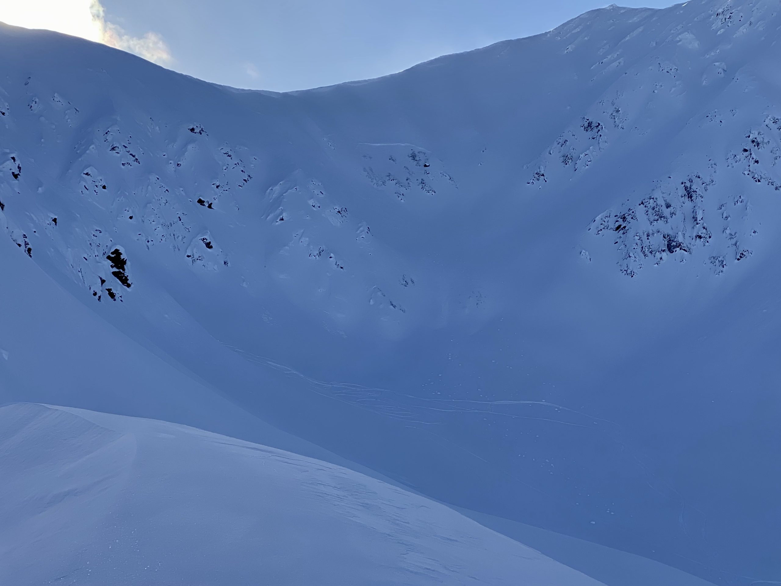
The avalanche danger is MODERATE above 1000′. Continued wind loading overnight will make human triggered avalanches 1-2′ deep possible at upper elevations. There are also several buried weak layers in the upper 3′ of the snowpack which may have been involved with a human triggered avalanche on Sunday 2/19/23. Larger human triggered avalanches 2-3′ deep are possible on these buried weak layers and triggering one of these layers is more likely if the sun is rapidly warming the snow surface. Below 1000′ the avalanche danger is LOW. 

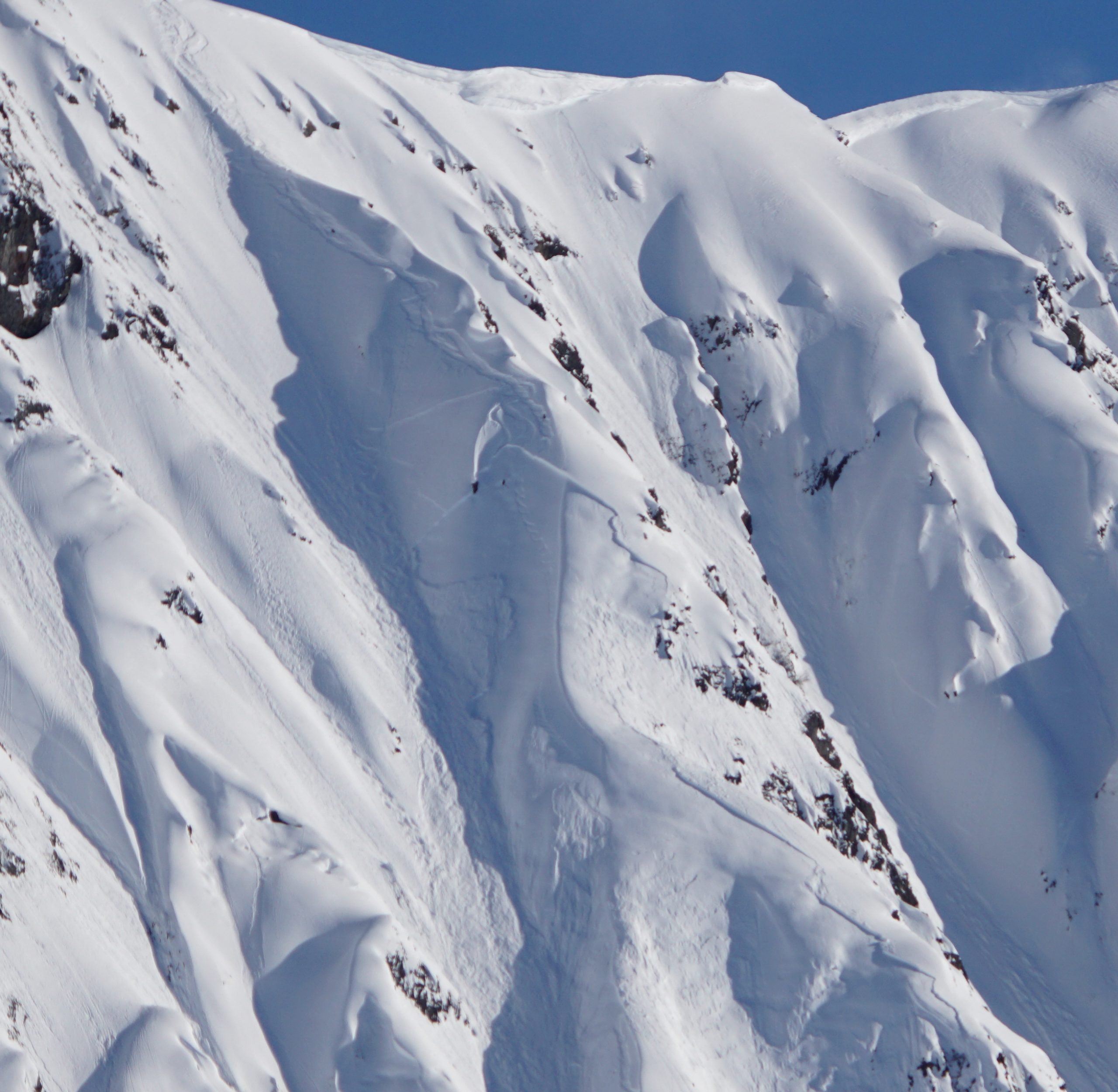
SUMMIT LAKE / LOST LAKE / SNUG HARBOR: Strong NW winds over the past 24 hours formed fresh wind slabs at upper elevations and may make existing buried weak layers more likely to produce avalanches. Identifying features of concern and testing surface avalanche conditions on small terrain features is recommended before committing to steeper terrain.

Tue, February 21st, 2023
Alpine
Above 2,500'
2 - Moderate
Avalanche risk
Treeline
1,000'-2,500'
2 - Moderate
Avalanche risk
Below Treeline
Below 1,000'
1 - Low
Avalanche risk
0 - No Rating
1 - Low
2 - Moderate
3 - Considerable
4 - High
5 - Extreme
Avalanche risk Avalanche risk Avalanche risk Avalanche risk Avalanche risk
Travel Advice Generally safe avalanche conditions. Watch for unstable snow on isolated terrain features. Heightened avalanche conditions on specific terrain features. Evaluate snow and terrain carefully; identify features of concern. Dangerous avalanche conditions. Careful snowpack evaluation, cautious route-finding, and conservative decision-making essential. Very dangerous avalanche conditions. Travel in avalanche terrain not recommended. Extraordinarily dangerous avalanche conditions. Avoid all avalanche terrain.
Likelihood of Avalanches Natural and human-triggered avalanches unlikely. Natural avalanches unlikely; human-triggered avalanches possible. Natural avalanches possible; human-triggered avalanches likely. Natural avalanches likely; human-triggered avalanches very likely. Natural and human-triggered avalanches certain.
Avalanche Size and Distribution Small avalanches in isolated areas or extreme terrain. Small avalanches in specific areas; or large avalanches in isolated areas. Small avalanches in many areas; or large avalanches in specific areas; or very large avalanches in isolated areas. Large avalanches in many areas; or very large avalanches in specific areas. Very large avalanches in many areas.
Recent Avalanches

No new avalanches were reported yesterday, other than some small wind slabs and loose snow avalanches releasing naturally in the upper Lynx Creek area. There was one larger slab in upper Lynx Creek but we are uncertain about the age due to all the recent wind activity. Otherwise more details have emerged from the Tincan Library avalanche that occurred on Sunday 2/19/23. Based on photos and investigation of the debris it looks like this avalanche failed on some kind of persistent weak layer within the upper 3′ of the snowpack, due to the wide propagation around several terrain features. Our best guess is that the strong solar input on Sunday afternoon was enough to make the surface snow act more like a slab which made whatever weak layer was lingering below the surface become more reactive despite not having any new snow added. This rapid solar warming is going to become more of a concern from here onward for the rest of the season. Check out the incident write up here for more information.

Mid-slope slab avalanche of unknown age from upper Lynx Creek area. Photo 2.20.23

Overview of Tincan Library avalanche with a person in the bottom right corner for scale. Photo 2.20.23 from Andy Moderow

Close up view of the crown from Tincan Library avalanche, based on width of propagation across multiple terrain features and the fact that it was the third skier on slope who triggered the avalanche we think some kind of persistent weak layer was involved. Photo 2.20.23 from Andy Moderow

Avalanche Problem 1
  • Wind Slabs
    Wind Slabs
  • Aspect/Elevation
  • Certain
    Very Likely
    Likely
    Possible
    Unlikely
    Likelihood
  • Historic (D4-5)
    Very Large (D3)
    Large (D2)
    Small (D1)
    Size
Wind Slabs
Wind Slab avalanches are the release of a cohesive layer of snow (a slab) formed by the wind. Wind typically transports snow from the upwind sides of terrain features and deposits snow on the downwind side. Wind slabs are often smooth and rounded and sometimes sound hollow, and can range from soft to hard. Wind slabs that form over a persistent weak layer (surface hoar, depth hoar, or near-surface facets) may be termed Persistent Slabs or may develop into Persistent Slabs.

Aspect/Elevation of the Avalanche Problem
Specialists develop a graphic representation of the potential distribution of a particular avalanche problem across the topography. This aspect/elevation rose is used to indicate where the particular avalanche problem is thought to exist on all elevation aspects. Areas where the avalanche problem is thought to exist are colored grey, and it is less likely to be encountered in areas colored white.

Likelihood of Avalanches
Terms such as "unlikely", "likely", and "certain" are used to define the scale, with the chance of triggering or observing avalanches increasing as we move up the scale. For our purposes, "Unlikely" means that few avalanches could be triggered in avalanche terrain and natural avalanches are not expected. "Certain" means that humans will be able to trigger avalanches on many slopes, and natural avalanches are expected.

Size of Avalanches
Avalanche size is defined by the largest potential avalanche, or expected range of sizes related to the problem in question. Assigned size is a qualitative estimate based on the destructive classification system and requires specialists to estimate the harm avalanches may cause to hypothetical objects located in the avalanche track (AAA 2016, CAA 2014). Under this schema, "Small" avalanches are not large enough to bury humans and are relatively harmless unless they carry people over cliffs or through trees or rocks. Moving up the scale, avalanches become "Large" enough to bury, injure, or kill people. "Very Large" avalanches may bury or destroy vehicles or houses, and "Historic" avalanches are massive events capable of altering the landscape.

Signal Word Size (D scale) Simple Descriptor
Small 1 Unlikely to bury a person
Large 2 Can bury a person
Very Large 3 Can destroy a house
Historic 4 & 5 Can destroy part or all of a village
More info at Avalanche.org

The windy conditions that impacted the mountains yesterday have lingered overnight and as of 5 am the average wind speeds remain in the 5-15 mph range out of the NW with gusts up to 30 mph. We expect the winds to die down this morning and give way to a calmer day but wind slabs 1-2′ deep that formed overnight could remain touchy today. Human triggered avalanches are possible in areas that have seen recent wind loading, like along upper elevation ridgelines and cross loaded gullies. To identify areas with recent wind slabs you can feel for stiffer or hollow feeling snow on the surface and use small test slopes to check how reactive the surface snow is.

The sun should be back out this morning and may have an impact on the snow surface again, however clouds are expected to move into the area throughout the day which might limit the amount of solar warming today. Loose snow avalanches on solar aspects (east, south, west) could release naturally especially in areas where the sun is warming up rocky areas above steeper terrain. Cornice fall is also more likely with direct solar warming so try to be aware of any large cornices overhead that are baking in the sun.

Example of recently wind scoured surface texture from Sunburst, which indicates that the leeward slope where the snow was transported could be harboring a wind slab. Photo 2.19.23 from Megan Guinn

Avalanche Problem 2
  • Persistent Slabs
    Persistent Slabs
  • Aspect/Elevation
  • Certain
    Very Likely
    Likely
    Possible
    Unlikely
    Likelihood
  • Historic (D4-5)
    Very Large (D3)
    Large (D2)
    Small (D1)
    Size
Persistent Slabs
Persistent Slab avalanches are the release of a cohesive layer of snow (a slab) in the middle to upper snowpack, when the bond to an underlying persistent weak layer breaks. Persistent layers include: surface hoar, depth hoar, near-surface facets, or faceted snow. Persistent weak layers can continue to produce avalanches for days, weeks or even months, making them especially dangerous and tricky. As additional snow and wind events build a thicker slab on top of the persistent weak layer, this avalanche problem may develop into a Deep Persistent Slab.

Aspect/Elevation of the Avalanche Problem
Specialists develop a graphic representation of the potential distribution of a particular avalanche problem across the topography. This aspect/elevation rose is used to indicate where the particular avalanche problem is thought to exist on all elevation aspects. Areas where the avalanche problem is thought to exist are colored grey, and it is less likely to be encountered in areas colored white.

Likelihood of Avalanches
Terms such as "unlikely", "likely", and "certain" are used to define the scale, with the chance of triggering or observing avalanches increasing as we move up the scale. For our purposes, "Unlikely" means that few avalanches could be triggered in avalanche terrain and natural avalanches are not expected. "Certain" means that humans will be able to trigger avalanches on many slopes, and natural avalanches are expected.

Size of Avalanches
Avalanche size is defined by the largest potential avalanche, or expected range of sizes related to the problem in question. Assigned size is a qualitative estimate based on the destructive classification system and requires specialists to estimate the harm avalanches may cause to hypothetical objects located in the avalanche track (AAA 2016, CAA 2014). Under this schema, "Small" avalanches are not large enough to bury humans and are relatively harmless unless they carry people over cliffs or through trees or rocks. Moving up the scale, avalanches become "Large" enough to bury, injure, or kill people. "Very Large" avalanches may bury or destroy vehicles or houses, and "Historic" avalanches are massive events capable of altering the landscape.

Signal Word Size (D scale) Simple Descriptor
Small 1 Unlikely to bury a person
Large 2 Can bury a person
Very Large 3 Can destroy a house
Historic 4 & 5 Can destroy part or all of a village
More info at Avalanche.org

Based on the follow up investigation of the Tincan Library accident (details here) we think a weak layer of buried surface hoar or facets in the upper 3′ of the snowpack might have been involved in this avalanche. The area was experiencing rapid solar warming in the hours prior to the avalanche releasing which may have allowed the surface snow to act like more of a slab then it did when it was cold and dry. This transition to a stiffer slab on top on solar aspects may cause shallowly buried persistent weak layers to become more reactive, like the 2/15 buried surface hoar about 6-12″ deep or the 2/5 facets about 1.5-2.5′ down. Below 2000′ the 2/5 facet layer transitions to a melt freeze crust with facets around it. To check for these layers in the area you are travelling we recommend paying close attention to surface conditions by using small test slopes, hand pits, or snow pits. A snow pit is the best way to identify persistent weak layers in the snowpack and test their strength and propagation potential.

Deeper in the snowpack the 1/10 buried surface hoar is about 2-4′ down in Turnagain Pass. This layer has been largely unreactive in the past few weeks with the exception of a few concerning snow pit tests from isolated areas where the surface hoar grains were well preserved. On the southern end of the forecast area and thinner snowpack areas like Summit Lake very large avalanches releasing on this layer could still be a concern, especially if the snowpack has seen recent wind loading.

Additional Concern
  • Deep Persistent Slabs
    Deep Persistent Slabs
Deep Persistent Slabs
Deep Persistent Slab avalanches are the release of a thick cohesive layer of hard snow (a slab), when the bond breaks between the slab and an underlying persistent weak layer deep in the snowpack. The most common persistent weak layers involved in deep, persistent slabs are depth hoar or facets surrounding a deeply buried crust. Deep Persistent Slabs are typically hard to trigger, are very destructive and dangerous due to the large mass of snow involved, and can persist for months once developed. They are often triggered from areas where the snow is shallow and weak, and are particularly difficult to forecast for and manage.
More info at Avalanche.org

In areas with a thin snowpack (i.e. Silvertip and the southern end of the forecast region to Summit Lake) there are various weak layers near the base of the snowpack that remain a concern. For these areas, triggering a larger avalanche is not totally out of the question and a more cautious mindset is recommended.

Weather
Tue, February 21st, 2023

Yesterday: Mostly clear skies with temperatures in the teens at upper elevations and mid 20s F at lower elevations. Moderate to strong NW winds averaging 5-15 mph at upper elevations with gusts up to 40 mph along Turnagain Arm. No new snow or rain.

Today: Winds should quiet down this morning and remain light at 5-10 mph for the remainder of the day. Cloud cover will move into the area around noon with gradually descending cloud levels throughout the day. Light snow is possible overnight tonight with just a trace of accumulation. Snow line will remain at sea level.

Tomorrow: Mostly cloudy with light snowfall possible but minimal accumulation. Temperatures should increase slightly with the cloud cover reaching the low 20s at upper elevations and high 20s at lower elevations. Winds will remain light at 5-10 mph.

PRECIPITATION 24-hour data (6am – 6am)

Temp Avg (F) Snow (in) Water (in) Snow Depth (in)
Center Ridge (1880′) 21 0 0 68
Summit Lake (1400′) 16 0 0 36
Alyeska Mid (1700′) 20 0 0 72
Bear Valley – Portage (132′) 27 0 0

RIDGETOP 24-hour data (6am – 6am)

Temp Avg (F) Wind Dir Wind Avg (mph) Wind Gust (mph)
Sunburst (3812′) 12 NW 8 27
Seattle Ridge (2400′) 17 NW 8 27
Observations
Recent Observations for Turnagain Pass
Date Region Location
04/21/24 Turnagain Observation: Bertha Creek
04/20/24 Turnagain Avalanche: Spokane Creek
04/16/24 Turnagain Observation: Cornbiscuit
04/15/24 Turnagain Observation: Taylor Pass
04/15/24 Turnagain Observation: Seward Highway – Tern Lake to Portage
04/14/24 Turnagain Observation: Sunburst
04/14/24 Turnagain Observation: Turnagain Pass Snomo
04/13/24 Turnagain Observation: Spokane Creek
04/11/24 Turnagain Observation: Tincan
04/10/24 Turnagain Avalanche: Seattle Ridge
Riding Areas

The riding areas page has moved. Please click here & update your bookmarks.


Subscribe to Turnagain Pass
Avalanche Forecast by Email

This is a general backcountry avalanche advisory issued for Turnagain Arm with Turnagain Pass as the core advisory area. This advisory does not apply to highways, railroads or operating ski areas.