Turnagain Pass Avalanche Forecast RSS

Archives
ARCHIVED FORECAST - All forecasts expire after 24 hours from the posting date/time.
Issued
Sat, February 18th, 2023 - 7:00AM
Expires
Sun, February 19th, 2023 - 7:00AM
Forecaster
John Sykes
Avalanche risk The Bottom Line

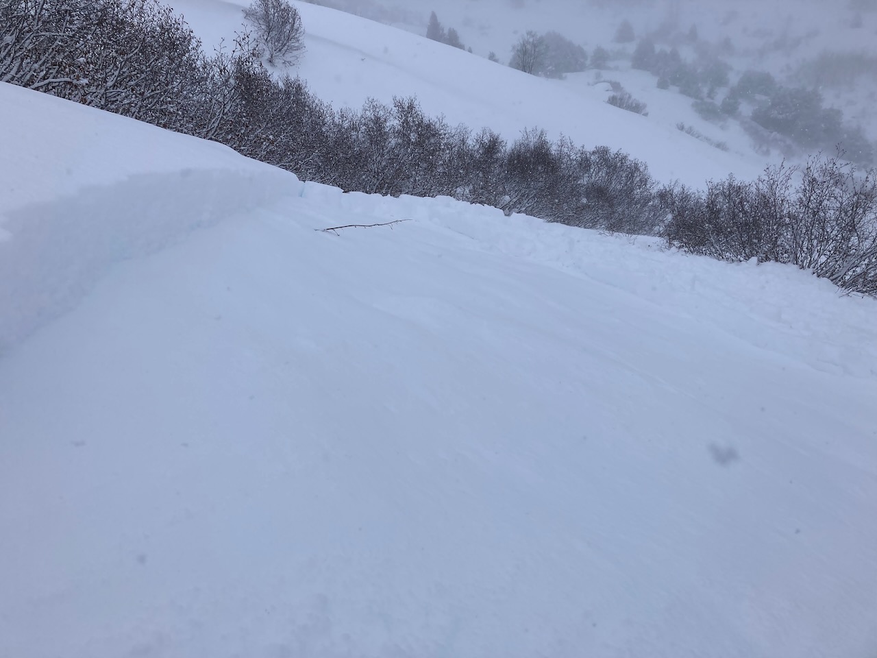
The avalanche danger is CONSIDERABLE above 2500′. Active wind loading and snowfall today will build fresh wind slabs 1-2′ deep that are likely for a person to trigger and possible to cause natural avalanches. Wind slabs are most likely to be found at upper elevations along ridgelines and cross loaded gullies. In addition there are buried weak layers in the snowpack that could cause larger avalanches 2-4′ deep in specific areas. Below 2500′ the avalanche danger is MODERATE. Wind slabs are possible and buried weak layers also exist at these elevations.

SUMMIT LAKE / LOST LAKE / SNUG HARBOR: Active weather today will increase avalanche danger at upper elevations and increase the chances of buried weak layers becoming active again, especially in areas with a thin overall snowpack. Conservative terrain selection and careful evaluation of the snowpack is recommended.

Thanks to our sponsors!
Sat, February 18th, 2023
Alpine
Above 2,500'
Considerable (3)
Avalanche risk
Treeline
1,000'-2,500'
Moderate (2)
Avalanche risk
Below Treeline
Below 1,000'
Moderate (2)
Avalanche risk
Alpine
Above 2,500'
Avalanche risk
Considerable (3)
Treeline
1,000'-2,500'
Avalanche risk
Moderate (2)
Below Treeline
Below 1,000'
Avalanche risk
Moderate (2)
Danger Scale:
No Rating (0)
Low (1)
Moderate (2)
Considerable (3)
High (4)
Extreme (5)
Recent Avalanches

On Friday a skier triggered avalanche from the Crow Creek area was reported. The avalanche occurred at 1900′ on a SSW aspect and was about 20″ deep. The weak layer was reported to be a layer of surface hoar or facets above the 1/25 melt freeze crust. The skier also observed shooting cracks in the area prior to triggering this avalanche. Otherwise, during a brief clear period we did not see any recent avalanches in Turnagain Pass yesterday but plenty of signs of recent wind transport at upper elevations.

Skier triggered avalanche about 20″ deep by 60′ wide on a weak layer above the 1/25 crust in the Crow Creek area. Photo 2.17.23 from Malcolm H

Avalanche Problem 1
  • Wind Slabs
    Wind Slabs
  • Aspect/Elevation
  • Almost Certain
    Very Likely
    Likely
    Possible
    Unlikely
    Likelihood
  • Historic (D4-5)
    Very Large (D3)
    Large (D2)
    Small (D1)
    Size
Wind Slabs
Wind Slab avalanches are the release of a cohesive layer of snow (a slab) formed by the wind. Wind typically transports snow from the upwind sides of terrain features and deposits snow on the downwind side. Wind slabs are often smooth and rounded and sometimes sound hollow, and can range from soft to hard. Wind slabs that form over a persistent weak layer (surface hoar, depth hoar, or near-surface facets) may be termed Persistent Slabs or may develop into Persistent Slabs.

Aspect/Elevation of the Avalanche Problem
Specialists develop a graphic representation of the potential distribution of a particular avalanche problem across the topography. This aspect/elevation rose is used to indicate where the particular avalanche problem is thought to exist on all elevation aspects. Areas where the avalanche problem is thought to exist are colored grey, and it is less likely to be encountered in areas colored white.

Likelihood of Avalanches
Terms such as "unlikely", "likely", and "certain" are used to define the scale, with the chance of triggering or observing avalanches increasing as we move up the scale. For our purposes, "Unlikely" means that few avalanches could be triggered in avalanche terrain and natural avalanches are not expected. "Certain" means that humans will be able to trigger avalanches on many slopes, and natural avalanches are expected.

Size of Avalanches
Avalanche size is defined by the largest potential avalanche, or expected range of sizes related to the problem in question. Assigned size is a qualitative estimate based on the destructive classification system and requires specialists to estimate the harm avalanches may cause to hypothetical objects located in the avalanche track (AAA 2016, CAA 2014). Under this schema, "Small" avalanches are not large enough to bury humans and are relatively harmless unless they carry people over cliffs or through trees or rocks. Moving up the scale, avalanches become "Large" enough to bury, injure, or kill people. "Very Large" avalanches may bury or destroy vehicles or houses, and "Historic" avalanches are massive events capable of altering the landscape.

Signal Word Size (D scale) Simple Descriptor
Small 1 Unlikely to bury a person
Large 2 Can bury a person
Very Large 3 Can destroy a house
Historic 4 & 5 Can destroy part or all of a village
More info at Avalanche.org

We are expecting another storm system today with pretty low snowfall amounts but moderate to strong winds that will be able to transport the soft surface snow into fresh wind slabs 1-2′ deep. Snowfall totals will vary from 1-3″ in Turnagain Pass, Girdwood, and Summit Lake to 6-12″ near Portage. Cloud cover is expected to remain throughout the day so accessing higher elevation terrain where wind slabs are most likely to form will likely be challenging due to visibility.

To identify areas harboring wind slabs look for shooting cracks, signs of recent wind transport, and hollow feeling snow on the surface. Jumping on small, steep, wind loaded terrain features can be a very effective way to get a sense of how touchy wind slabs are before committing to larger slopes. In areas receiving active wind loading today, like along upper elevation ridgelines and cross loaded gullies, human triggered avalanches are likely.

NWS snowfall estimates from Saturday morning through Sunday morning. Graphic courtesy of NWS Anchorage 2.18.23


Avalanche Problem 2
  • Persistent Slabs
    Persistent Slabs
  • Aspect/Elevation
  • Almost Certain
    Very Likely
    Likely
    Possible
    Unlikely
    Likelihood
  • Historic (D4-5)
    Very Large (D3)
    Large (D2)
    Small (D1)
    Size
Persistent Slabs
Persistent Slab avalanches are the release of a cohesive layer of snow (a slab) in the middle to upper snowpack, when the bond to an underlying persistent weak layer breaks. Persistent layers include: surface hoar, depth hoar, near-surface facets, or faceted snow. Persistent weak layers can continue to produce avalanches for days, weeks or even months, making them especially dangerous and tricky. As additional snow and wind events build a thicker slab on top of the persistent weak layer, this avalanche problem may develop into a Deep Persistent Slab.

Aspect/Elevation of the Avalanche Problem
Specialists develop a graphic representation of the potential distribution of a particular avalanche problem across the topography. This aspect/elevation rose is used to indicate where the particular avalanche problem is thought to exist on all elevation aspects. Areas where the avalanche problem is thought to exist are colored grey, and it is less likely to be encountered in areas colored white.

Likelihood of Avalanches
Terms such as "unlikely", "likely", and "certain" are used to define the scale, with the chance of triggering or observing avalanches increasing as we move up the scale. For our purposes, "Unlikely" means that few avalanches could be triggered in avalanche terrain and natural avalanches are not expected. "Certain" means that humans will be able to trigger avalanches on many slopes, and natural avalanches are expected.

Size of Avalanches
Avalanche size is defined by the largest potential avalanche, or expected range of sizes related to the problem in question. Assigned size is a qualitative estimate based on the destructive classification system and requires specialists to estimate the harm avalanches may cause to hypothetical objects located in the avalanche track (AAA 2016, CAA 2014). Under this schema, "Small" avalanches are not large enough to bury humans and are relatively harmless unless they carry people over cliffs or through trees or rocks. Moving up the scale, avalanches become "Large" enough to bury, injure, or kill people. "Very Large" avalanches may bury or destroy vehicles or houses, and "Historic" avalanches are massive events capable of altering the landscape.

Signal Word Size (D scale) Simple Descriptor
Small 1 Unlikely to bury a person
Large 2 Can bury a person
Very Large 3 Can destroy a house
Historic 4 & 5 Can destroy part or all of a village
More info at Avalanche.org

In addition to the wind slab problem on the surface we also have several buried weak layers in the snowpack that could produce larger avalanches. The most likely buried weak layers to trigger an avalanche on are in the upper 1-2′ of the snowpack and include a new layer of surface hoar that was buried on 2/15 and the storm snow interface from 2/5. Yesterday several groups reported propagation in snow pit tests on the newest layer of buried surface hoar from 2/15 about 4-6″ deep. This layer could now have fresh wind slabs on top which might cause surface avalanches to be larger and more reactive than typical. The 2/5 storm interface looks like a layer of weaker faceted snow 1.5-2.5′ deep at upper elevations but below 2000′ it is a layer of facets on top of the 1/25 melt freeze crust. The recent avalanche from Crow Creek Area likely failed on this layer of facets above the 1/25 melt freeze crust.

Deeper down in the snowpack the 1/10 buried surface hoar continues to show occasional signs of instability in snowpit tests. Over the past few weeks we have been able to find unstable results in snowpits in areas near treeline where the layer is well preserved and there has not been much skier traffic. The depth to this weak layer varies depending on location. In areas like Portage, where there has been a lot more snowfall in recent weeks, it is buried up to 5’+ deep and is unlikely to be triggered by a person. In thinner areas like near Johnson Pass trailhead (Lynx Creek, Pete’s, Silvertip) this layer is closer to 2-3′ deep and it is still possible for a person to trigger an avalanche in isolated locations.

The layer of facets at the 2/5 interface showed signs of instability in some but not all of our snowpit tests yesterday. Photo 2.17.23

Additional Concern
  • Deep Persistent Slabs
    Deep Persistent Slabs
Deep Persistent Slabs
Deep Persistent Slab avalanches are the release of a thick cohesive layer of hard snow (a slab), when the bond breaks between the slab and an underlying persistent weak layer deep in the snowpack. The most common persistent weak layers involved in deep, persistent slabs are depth hoar or facets surrounding a deeply buried crust. Deep Persistent Slabs are typically hard to trigger, are very destructive and dangerous due to the large mass of snow involved, and can persist for months once developed. They are often triggered from areas where the snow is shallow and weak, and are particularly difficult to forecast for and manage.
More info at Avalanche.org

In areas with a thin overall snowpack, like near Silvertip and the southern end of the forecast region, there are deeper weak layers near the base of the snowpack that are concerning. The most widespread weak layer is the Thanksgiving facet/crust combo but in some areas there is also a weak layer of basal facets that is concerning. With active weather today it is possible that these deeper weak layer could become active again and produce very large avalanches.

Weather
Sat, February 18th, 2023

Yesterday: Obscured cloud cover and light snow in the morning with moderate winds in the 10-20 mph range at upper elevations with gusts to the mid 30s. Winds briefly shifted to the west during the middle of the day and decreased to 5-15 mph with gusts into 20s. Overnight the winds shifted back to the east and increased to 10-20 mph with gusts into the 30s. 1-2″ of new snow fell over the last 24 hours. Temperatures remained in the teens to low 20s at upper elevations. At lower elevations the clearing clouds and shift to west winds brought a brief period of colder temps in the teens but most of the last 24 hours temperatures have been in the low 30s.

Today: Light snowfall and moderate winds should persist through this afternoon, with 1-6″ of snow expected depending on location. Winds will reach 15-25 mph with gusts of 35-50 mph during the peak of the snowfall. Snow line should remain close to sea level today with temperatures in the 20s at upper elevations and low 30s at lower elevations.

 Tomorrow: Clearing skies and moderate NW outflow winds are expected to start overnight on Saturday. Sunday looks like it should be mostly clear with temperatures dropping into the teens at upper elevations. No new snowfall is expected on Sunday. Gap winds are typically strongest along Turnagain Arm and tend to impact the mountains along Seattle Ridge and Summit Lake more strongly than the skiers side of Turnagain Pass.

PRECIPITATION 24-hour data (6am – 6am)

Temp Avg (F) Snow (in) Water (in) Snow Depth (in)
Center Ridge (1880′) 27 1 0.1 68
Summit Lake (1400′) 24 1 0.1 36
Alyeska Mid (1700′) 26 1 0.1 72
Bear Valley – Portage (132′) 28 2 0.15

RIDGETOP 24-hour data (6am – 6am)

Temp Avg (F) Wind Dir Wind Avg (mph) Wind Gust (mph)
Sunburst (3812′) 17 ENE 8 35
Seattle Ridge (2400′) 22 SE 5 17
Observations
Recent Observations for Turnagain Pass
Date Region Location
03/19/23 Turnagain Observation: Tin Can
03/19/23 Turnagain Avalanche: Tincan
03/18/23 Turnagain Observation: Turnagain Pass – valley bottoms
03/17/23 Turnagain Observation: Tincan
03/17/23 Turnagain Observation: Eddie’s/Summit
03/16/23 Turnagain Observation: Twin Peaks Meadows
03/16/23 Turnagain Avalanche: Tincan
03/16/23 Turnagain Avalanche/People Involved: Tincan Trees
03/16/23 Turnagain Avalanche/People Involved: Tincan Common
03/15/23 Turnagain Observation: Tincan
Riding Areas
Updated Fri, February 10th, 2023

Status of riding areas across the Chugach NF is managed by the Glacier and Seward Ranger Districts, not avalanche center staff. Riding area information is posted as a public service to our users and updated based on snow depth and snow density to prevent resource damage at trailhead locations. Riding area questions contact: mailroom_r10_chugach@fs.fed.us

Area Status Weather & Riding Conditions
Glacier District
Johnson Pass
Open
Opened Dec 13th.
Placer River
Open
Closed Jan 5th due to lack of snow and reopened Feb 11th.
Skookum Drainage
Open
Closed Jan 5th due to lack of snow and reopened Feb 11th.
Turnagain Pass
Open
Opened Dec 13th.
Twentymile
Open
Closed Jan 5th due to lack of snow and reopened Feb 11th.
Seward District
Carter Lake
Open
Opened Dec 13th.
Lost Lake Trail
Open
Opened Dec 13th.
Primrose Trail
Open
Opened Dec 13th.
Resurrection Pass Trail
Closed
Closed to motorized use for the 2022/23 winter season per Forest Plan. Open next season.
Snug Harbor
Open
Opened Dec 13th.
South Fork Snow River Corridor
Open
Opened Dec 13th.
Summit Lake
Open
Opened Dec 13th.

Subscribe to Turnagain Pass
Avalanche Forecast by Email

This is a general backcountry avalanche advisory issued for Turnagain Arm with Turnagain Pass as the core advisory area. This advisory does not apply to highways, railroads or operating ski areas.