Turnagain Pass RSS

Archives
ARCHIVED - Forecasts expire after 24 hours.
Issued
Thu, February 17th, 2022 - 7:00AM
Expires
Fri, February 18th, 2022 - 7:00AM
Forecaster
John Sykes
Avalanche risk The Bottom Line

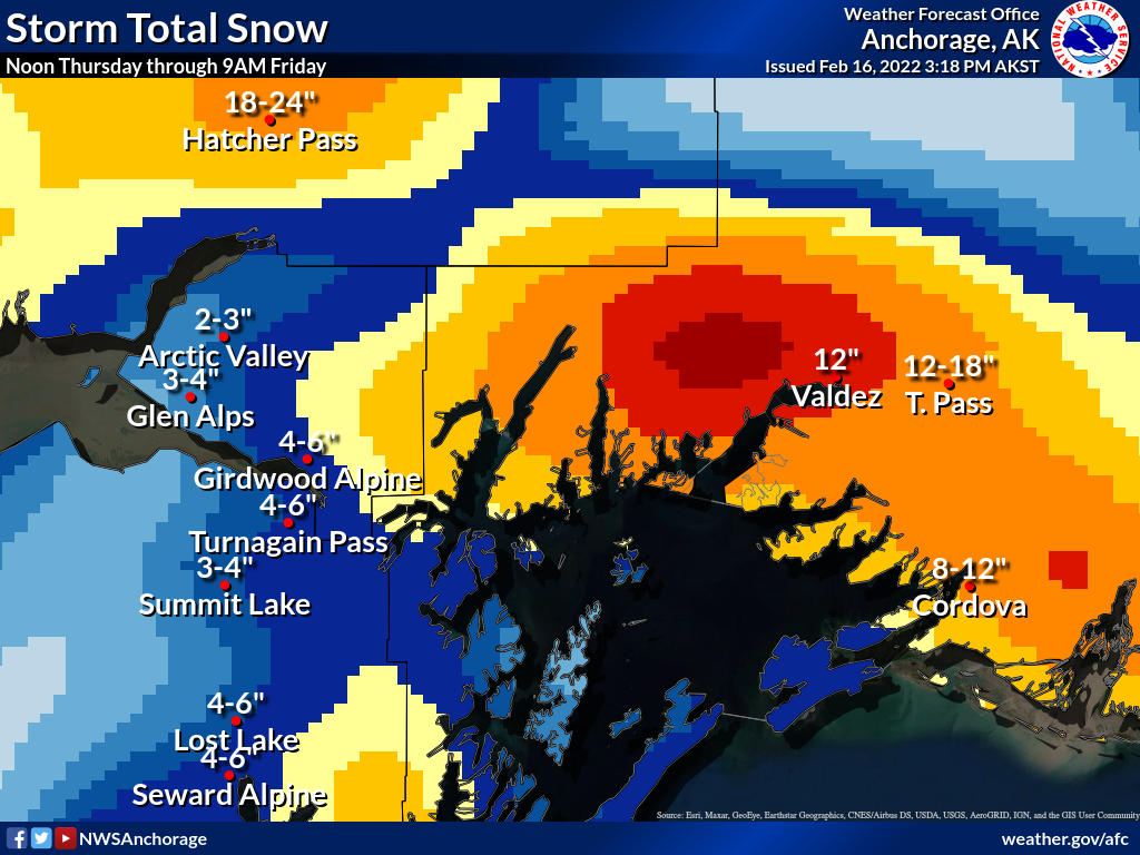
The avalanche danger is CONSIDERABLE above 2500′ today. Lingering wind slabs up to 2′ deep that formed yesterday are likely for a person to trigger at higher elevations and in steeper terrain. Another storm is approaching this afternoon which will bring 6-12″ of snowfall to the forecast area and will increase avalanche danger this evening and overnight. Below 2500′ the avalanche danger is MODERATE. Wind slabs are possible for a person to trigger in exposed terrain. Loose snow avalanches in steeper terrain are likely and could include loose wet avalanches below 1000′.

Special Announcements
  • Hatcher Pass Avalanche Center issued an Avalanche Warning yesterday with HIGH avalanche danger. More snowfall today and into tomorrow will cause continued very dangerous avalanche conditions in the area.  Stay tuned to HPAC for more information.
  • Western Kenai Peninsula- NWS Special Weather Statement for mixed snow and rain late Thursday morning through Friday morning
  • Matanuska Valley – NWS Winter Weather Advisory for 6-10″ snowfall
Thu, February 17th, 2022
Alpine
Above 2,500'
3 - Considerable
Avalanche risk
Treeline
1,000'-2,500'
2 - Moderate
Avalanche risk
Below Treeline
Below 1,000'
2 - Moderate
Avalanche risk
0 - No Rating
1 - Low
2 - Moderate
3 - Considerable
4 - High
5 - Extreme
Avalanche risk Avalanche risk Avalanche risk Avalanche risk Avalanche risk
Travel Advice Generally safe avalanche conditions. Watch for unstable snow on isolated terrain features. Heightened avalanche conditions on specific terrain features. Evaluate snow and terrain carefully; identify features of concern. Dangerous avalanche conditions. Careful snowpack evaluation, cautious route-finding, and conservative decision-making essential. Very dangerous avalanche conditions. Travel in avalanche terrain not recommended. Extraordinarily dangerous avalanche conditions. Avoid all avalanche terrain.
Likelihood of Avalanches Natural and human-triggered avalanches unlikely. Natural avalanches unlikely; human-triggered avalanches possible. Natural avalanches possible; human-triggered avalanches likely. Natural avalanches likely; human-triggered avalanches very likely. Natural and human-triggered avalanches certain.
Avalanche Size and Distribution Small avalanches in isolated areas or extreme terrain. Small avalanches in specific areas; or large avalanches in isolated areas. Small avalanches in many areas; or large avalanches in specific areas; or very large avalanches in isolated areas. Large avalanches in many areas; or very large avalanches in specific areas. Very large avalanches in many areas.
Avalanche Problem 1
  • Wind Slabs
    Wind Slabs
  • Certain
    Very Likely
    Likely
    Possible
    Unlikely
    Likelihood
  • Historic (D4-5)
    Very Large (D3)
    Large (D2)
    Small (D1)
    Size
Wind Slabs
Wind Slab avalanches are the release of a cohesive layer of snow (a slab) formed by the wind. Wind typically transports snow from the upwind sides of terrain features and deposits snow on the downwind side. Wind slabs are often smooth and rounded and sometimes sound hollow, and can range from soft to hard. Wind slabs that form over a persistent weak layer (surface hoar, depth hoar, or near-surface facets) may be termed Persistent Slabs or may develop into Persistent Slabs.

Likelihood of Avalanches
Terms such as "unlikely", "likely", and "certain" are used to define the scale, with the chance of triggering or observing avalanches increasing as we move up the scale. For our purposes, "Unlikely" means that few avalanches could be triggered in avalanche terrain and natural avalanches are not expected. "Certain" means that humans will be able to trigger avalanches on many slopes, and natural avalanches are expected.

Size of Avalanches
Avalanche size is defined by the largest potential avalanche, or expected range of sizes related to the problem in question. Assigned size is a qualitative estimate based on the destructive classification system and requires specialists to estimate the harm avalanches may cause to hypothetical objects located in the avalanche track (AAA 2016, CAA 2014). Under this schema, "Small" avalanches are not large enough to bury humans and are relatively harmless unless they carry people over cliffs or through trees or rocks. Moving up the scale, avalanches become "Large" enough to bury, injure, or kill people. "Very Large" avalanches may bury or destroy vehicles or houses, and "Historic" avalanches are massive events capable of altering the landscape.

Signal Word Size (D scale) Simple Descriptor
Small 1 Unlikely to bury a person
Large 2 Can bury a person
Very Large 3 Can destroy a house
Historic 4 & 5 Can destroy part or all of a village
More info at Avalanche.org

We will have a brief break between storms this morning before the next one arrives around 3 pm today, bringing another 6-12″ of new snow to the area overnight tonight. Slightly higher snowfall totals are expected for Girdwood, Portage, and Placer compared to Turnagain Pass. The heaviest snowfall with this storm will again be in Hatcher Pass, where another 18-24″ of snow is forecast.

We expect that the 4-10″ of new snow from yesterday will bond well to the old surface and slab avalanches in areas sheltered from the wind today are unlikely. The main avalanche problem before the next storm arrives will be wind slabs at higher elevations that were created yesterday, with winds averaging in the teens and gusting up to 40 mph at ridgetops. Wind slabs could be up to 2′ deep and will be likely for a person to trigger at upper elevations. Especially along ridgelines, in cross loaded gullies, and convex terrain features. Watch for shooting cracks, fresh wind drifts, and hollow feeling snow to identify wind loaded terrain features. Testing how reactive wind slabs are on small terrain features is a great way to evaluate the potential size of wind slabs before entering more consequential terrain.

Cornices: Added snowfall and wind will have built cornices a little larger yesterday, so be aware that they could be more reactive to human triggers today.

Loose Snow Avalanches: Dry loose avalanches (sluffs) are also likely at upper elevations in the new snow on steeper terrain features today. At lower elevations, wet loose avalanches are possible as well due to the warm temperatures towards the end of yesterday’s storm.

Expected snowfall totals from the next storm system. Hatcher Pass is still favored by the flow direction of this storm, and we expect slightly higher snowfall in Girdwood, Portage, and Placer compared to Turnagain. Graphic courtesy of NWS Anchorage 2.16.22

Additional Concern
  • Persistent Slabs
    Persistent Slabs
Persistent Slabs
Persistent Slab avalanches are the release of a cohesive layer of snow (a slab) in the middle to upper snowpack, when the bond to an underlying persistent weak layer breaks. Persistent layers include: surface hoar, depth hoar, near-surface facets, or faceted snow. Persistent weak layers can continue to produce avalanches for days, weeks or even months, making them especially dangerous and tricky. As additional snow and wind events build a thicker slab on top of the persistent weak layer, this avalanche problem may develop into a Deep Persistent Slab.
More info at Avalanche.org

In areas of the forecast zone with a shallow overall snowpack we are still dealing with weak layers that were buried in November and continue to be reactive in snow pits and produce both natural and human triggered avalanches. This widespread weak snowpack structure is concerning because of the potential to create large and wide propagating avalanches. For most of our core forecast area the snowpack is deep enough that these weak layers are not a huge concern, but on the margins of our forecast area and other regions that harbor a thin snowpack (e.g. Summit Lake) these layers should be evaluated carefully before entering avalanche terrain. Avalanche mitigation along the Seward Highway near Summit Lake yesterday produced several avalanches, including two with wide propagation and a long runout (see photo) that likely failed on a layer of buried facets from November.

Glide: In the past 10 days or so we have witnessed glide cracks opening up again in Turnagain Pass, most notably on Repeat Offender above the Seattle Ridge uptrack. Glide avalanches are very unpredictable and warrant avoiding spending time in their potential runout zone.

Results of avalanche mitigation work along Seward Highway yesterday. Multiple avalanches appeared to release on older buried weak layers and produce wide propagation. Photo 2.16.22 

Example of a thin snowpack from a wind swept area in Turnagain Pass which is harboring a concerning weak layer of facets about 1.5′ deep.  Photo Andy Moderow 2.15.22

Weather
Thu, February 17th, 2022

Yesterday: Snowfall throughout the day mixed with rain near sea level in some locations. Storm totals since 1 am Wednesday were 4-6″ of snow at Center Ridge and 6-10″ at Alyeska mid. Winds were averaging 10-20 mph with gusts up to 40 mph on Sunburst until 5 pm yesterday, then dropped off to single digits overnight. Temperatures cooled slightly overnight but are still hovering around freezing at 2000′.

Today: A brief pause in snowfall during the morning today before another wave starts around 3 pm, with 6-12″ of snowfall expected by Friday morning. Snow line should stay around 500′ during this storm. Winds will increase as the snowfall intensifies with averages of 15-25 mph and gusts into the 40s during the peak of the precipitation around midnight.

Tomorrow: Snowfall should stop early tomorrow morning and winds will switch to west during the day tomorrow at 10-20 mph. Cloud cover should thin on Friday but lingering low clouds could still cause poor visibility. Temperatures will gradually drop throughout the day into the teens at ridgetops and 20s at trailhead elevations for the weekend. Conditions look largely similar for Saturday and Sunday with patchy low clouds, light winds, cool temperatures, and no significant precipitation expected until early next week.

PRECIPITATION 24-hour data (6am – 6am)

Temp Avg (F) Snow (in) Water (in) Snow Depth (in)
Center Ridge (1880′) 31 3 0.3 93
Summit Lake (1400′) 29 2 0.2 42
Alyeska Mid (1700′) 30 4 0.4 NA

RIDGETOP 24-hour data (6am – 6am)

Temp Avg (F) Wind Dir Wind Avg (mph) Wind Gust (mph)
Sunburst (3812′) 24 W 10 39
Seattle Ridge (2400′) 25 E 5 20
Observations
Recent Observations for Turnagain Pass
Date Region Location
04/21/24 Turnagain Observation: Bertha Creek
04/20/24 Turnagain Avalanche: Spokane Creek
04/16/24 Turnagain Observation: Cornbiscuit
04/15/24 Turnagain Observation: Taylor Pass
04/15/24 Turnagain Observation: Seward Highway – Tern Lake to Portage
04/14/24 Turnagain Observation: Sunburst
04/14/24 Turnagain Observation: Turnagain Pass Snomo
04/13/24 Turnagain Observation: Spokane Creek
04/11/24 Turnagain Observation: Tincan
04/10/24 Turnagain Avalanche: Seattle Ridge
Riding Areas

The riding areas page has moved. Please click here & update your bookmarks.


Subscribe to Turnagain Pass
Avalanche Forecast by Email

This is a general backcountry avalanche advisory issued for Turnagain Arm with Turnagain Pass as the core advisory area. This advisory does not apply to highways, railroads or operating ski areas.