Turnagain Pass Avalanche Forecast
|
![]() ![]() |
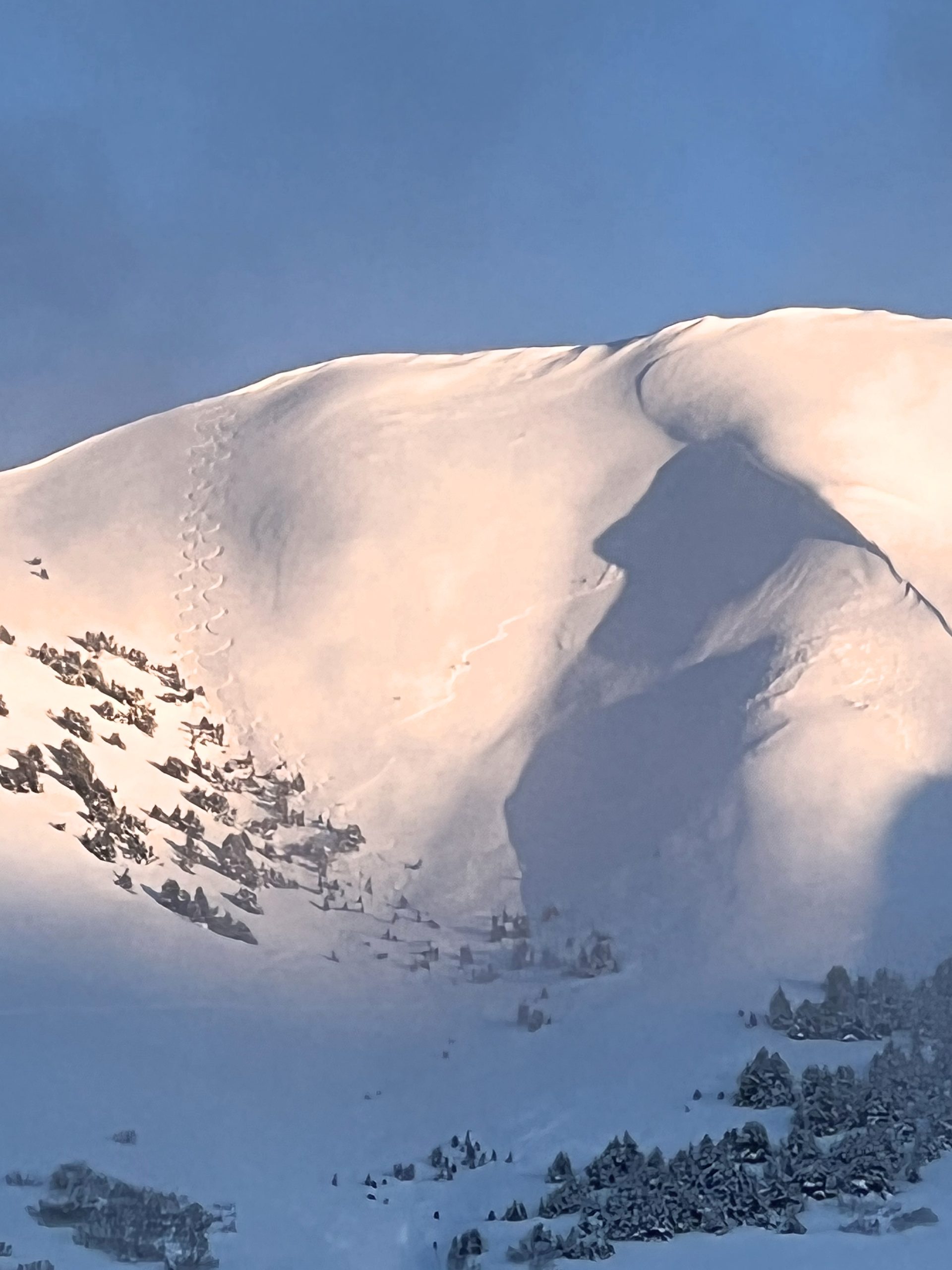
The avalanche danger is CONSIDERABLE at all elevations. We’ve received 6-10″ new snow in the past 24 hours, with winds blowing 30-50 mph and gusting up to 75 mph. It is likely a person can trigger an avalanche up to 2′ deep within the new snow, and possible to trigger larger avalanches deeper in the snowpack. Dangerous avalanche conditions will require cautious route-finding today, which will mean avoiding traveling on or below steep terrain.
SUMMIT LAKE: The snowpack in the Summit Lake area is thinner and weaker than the core advisory area. Snowfall should favor this area today as the storm passes, making avalanche conditions even more dangerous.
Join us on Valentine’s Day (Feb 14th) for Snowball! Dance to lively music by the Jangle Bees, bid on the silent auction, and enjoy 49th State Brewing libations and decadent desserts. Bring your sweetie or your best backcountry partners—or find new ones on the dance floor. All proceeds from this event benefit the Friends of the Chugach Avalanche Center and the Alaska Avalanche School, so you can let loose knowing it’s for a great cause! Tickets are limited, so get yours soon. Click here for tickets and more information.
There were no new avalanches reported yesterday, but it is likely there was some natural activity with the new snow and strong winds. Hopefully visibility will improve enough to get a better eye on things today.
Signal Word | Size (D scale) | Simple Descriptor |
Small | 1 | Unlikely to bury a person |
Large | 2 | Can bury a person |
Very Large | 3 | Can destroy a house |
Historic | 4 & 5 | Can destroy part or all of a village |
Yesterday’s storm brought 6-10″ low-density snow to the area, with easterly winds blowing 30-50 mph and gusts getting up to 75 mph. The system is moving out this morning and we should see fairly quiet conditions by the middle of the day, but all of that wind and new snow will make it likely a person can trigger a large avalanche even as the weather is calming down. If you are out traveling in the mountains today, keep a few things in mind:
Avalanches are most likely during and immediately after a storm, which is exactly where we will be today. If the snow and wind hang around longer than expected today, expect to see the avalanche danger rising. In addition to those problems within the new snow, remember we have a problem layer buried about 2-4′ deep now that has the potential to make even bigger avalanches. More on this in problem 2 below.
Signal Word | Size (D scale) | Simple Descriptor |
Small | 1 | Unlikely to bury a person |
Large | 2 | Can bury a person |
Very Large | 3 | Can destroy a house |
Historic | 4 & 5 | Can destroy part or all of a village |
We’ve been concerned with a layer of buried surface hoar for several weeks now. After yesterday’s storm, the layer is now buried somewhere around 2-4′ deep. This is the first loading event the layer has seen in over two weeks, and though it’s not a huge dump, it is pushing the needle towards instability. We should be treating this layer with a little extra caution for now, until we get a better idea of how it is responding to the new load. This is another good reason to tread lightly today, avoiding spending time on or below steep terrain.
This avalanche in the Summit Lake area failed on a weak layer in the upper snowpack and was likely triggered from low on the slope. Although this is outside of our advisory area, it is similar to the kind of activity that we can expect at Turnagain Pass and Girdwood today. Photo: Ryan McLaughlin, 02.04.2023
We haven’t forgotten about the problematic facet/crust combination buried 4-8′ deep in the snowpack. It is unlikely the new snow from the past 24 hours will be enough to significantly impact this weak layer. It is still unlikely a person will be able to trigger an avalanche this deep in the snowpack, but if you were to find a spot, it would be in an area with a thinner snowpack, and it could propagate across multiple terrain features on multiple aspects. Because of the small likelihood of triggering one of these very large avalanches, the more concerning issues for now still lie in the upper 2-4′ of the snowpack, and that will be enough to keep us out of big terrain for today.
Yesterday: We picked up 6-10” low density snow, with snow down to sea level for most of the storm, but rain sneaking up to around 300’ by early this morning. Winds have been blowing 30-50 mph out of the east with gusts reaching 65-75 mph. Temperatures climbed up from the mid 20’s F yesterday morning to the low 30’s F by the afternoon.
Today: Snowfall is tapering off and should finish late morning to early afternoon, with another 1-3” expected at Turnagain Pass and up to 6-9” possible in Girdwood and snow line dropping back to sea level. Winds should blow out of the east at 25-35 mph until later this morning when they shift more southerly and drop down to 5-15 mph. Skies will be cloudy with some breaks in the clouds this afternoon. Temperatures should hover in the upper 20’s to 30 F during the day, dropping into the mid to upper teens tonight.
Tomorrow: We should see some breaks in the clouds tomorrow during the day, with high temperatures in the low to mid 20’s F. Winds will be out of the east at 5-15 mph with gusts of 10-20 mph. Chances for precipitation pick up overnight and into Wednesday, with another inch or two of snow possible down to sea level.
PRECIPITATION 24-hour data (6am – 6am)
Temp Avg (F) | Snow (in) | Water (in) | Snow Depth (in) | |
---|---|---|---|---|
Center Ridge (1880′) | 28 | 10 (est) | 0.8 | 74 (est) |
Summit Lake (1400′) | 22 | 0 | 0 | 34 |
Alyeska Mid (1700′) | 26 | 8 | 0.6 | 69 |
Bear Valley – Portage (132′) | 35 | rain | 0.9 | – |
RIDGETOP 24-hour data (6am – 6am)
Temp Avg (F) | Wind Dir | Wind Avg (mph) | Wind Gust (mph) | |
---|---|---|---|---|
Sunburst (3812′) | 19 | ENE | 33 | 73 |
Seattle Ridge (2400′) | 23 | SE | 13 | 28 |
Date | Region | Location | Observer |
---|---|---|---|
05/22/23 | Turnagain | Avalanche: Tincan | Nick D'Alessio |
05/12/23 | Turnagain | Avalanche: Tincan, Sunburst, Magnum, Cornbiscuit | Heather Thamm |
05/07/23 | Turnagain | Observation: Tincan – Bear Tracks | CNFAIC Staff |
05/05/23 | Turnagain | Observation: Seattle Ridge | AS/ WW Forecaster |
05/02/23 | Turnagain | Observation: Cornbiscuit | Schauer/ Sturgess Forecaster |
05/02/23 | Turnagain | Observation: Seward Hwy Turnagain Pass | Joel Curtis |
04/30/23 | Turnagain | Observation: Magnum | Ayla, Kit Crosby, Barton |
04/29/23 | Turnagain | Observation: Tincan | John Sykes |
04/28/23 | Turnagain | Avalanche: Taylor Pass/Pastoral | Schauer/ Creighton Forecaster |
04/28/23 | Turnagain | Avalanche: Tincan | Andy Moderow |
Status of riding areas across the Chugach NF is managed by the Glacier and Seward Ranger Districts, not avalanche center staff. Riding area information is posted as a public service to our users and updated based on snow depth and snow density to prevent resource damage at trailhead locations. Riding area questions contact: mailroom_r10_chugach@fs.fed.us
Area | Status | Weather & Riding Conditions |
---|---|---|
Glacier District |
Subscribe to Turnagain Pass
Avalanche Forecast by Email
This is a general backcountry avalanche advisory issued for Turnagain Arm with Turnagain Pass as the core advisory area. This advisory does not apply to highways, railroads or operating ski areas.