| Trigger | Skier | Remote Trigger | No |
| Avalanche Type | Soft Slab | Aspect | Southwest |
| Elevation | 3800ft | Slope Angle | unknown |
| Crown Depth | 12in | Width | 500ft |
| Vertical Run | 2000ft |
Avalanche: Hatcher Pass
Location: Arkose Ridge, Mile 10, south side of the Little Su
Observed a skier triggered avalanche at approximately 2:30 pm today. We saw the powder cloud from Marmot and were able to watch the skier descend safely down the ridge. Skier performed a ski cut which resulted in a large avalanche ,SS-ASc-D2.5-I on a SW aspect . This avalanche wrapped the ridge to a NE aspect and stepped down into old weak facets. The majority of the slab failed on facets on the sun/drizzle crust.
Avalanche Details
Observed skier triggered avalanche while performing a ski cut. The avalanche wrapped the ridge from SW to NE approx 500 ft wide and ran approx 2000'. The avalanche failed on facets on the sun crust/drizzle crust and stepped down into older weaker facets and depth hoar in specific locations. The powder cloud could been seen from the top of Marmot.
Obvious signs of instability
| Recent Avalanches? | Yes |
| Collapsing (Whumphing)? | Yes |
| Cracking (Shooting cracks)? | No |
Observer Comments
Whumping felt on uptrack on SW ridge of Marmot today. Instability tests clearly showed propagation and slab failing in facets on sun crust/drizzle crust layer at 125 cm in the snowpack. Recent remotely triggered avalanche on punk spines 4/1 (see obs) and another human triggered near miss on the exit of gold chord lake 4/2(see obs).
Weather
No new snow today.
Significant warm up today, felt hot on the skin track. Intense solar radiation today.
Temps reported at IM averaged 15deg F but felt like Hawaii.
Snow surface
2-4" thick stout sun crusts on southerlies and westerly today. By 11:30 am crusts had softened on southerlies but not west aspects. Rimed stellars and graupel was observed on the surface.
Snowpack
4200' W aspect 34deg slope
CT 13 SP
CT 14 SP
ECTX
PST 20/100 end
*All tests failed in facets on sun crust/drizzle crust at 125 cm (50"), approx 60 cm deep (24")
This is the culprit weak layer from all the recent avalanches this week.
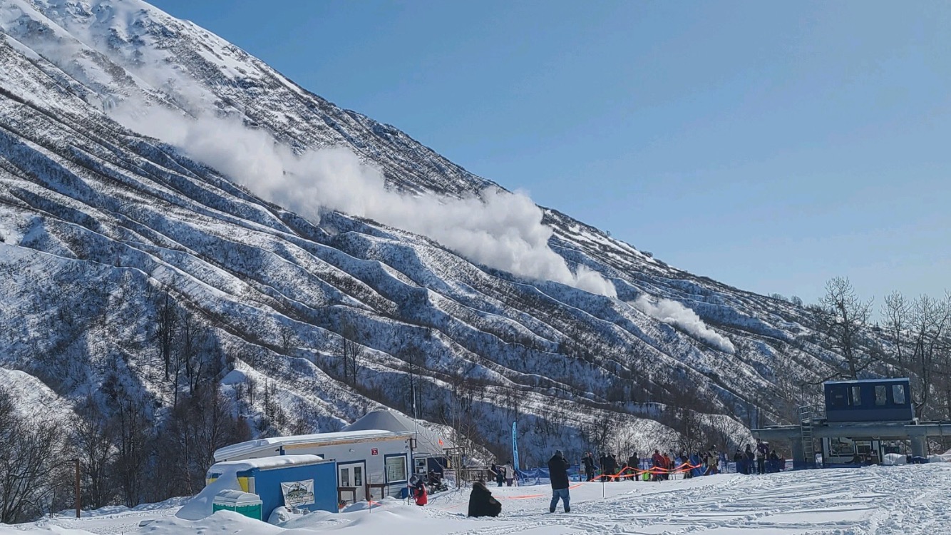
Powdercloud from avalanche

Large human triggered avalanche that wrapped the ridge from SW to NE and stepped down into old facets and depth hoar.

Large human triggered avalanche that wrapped the ridge from SW to NE